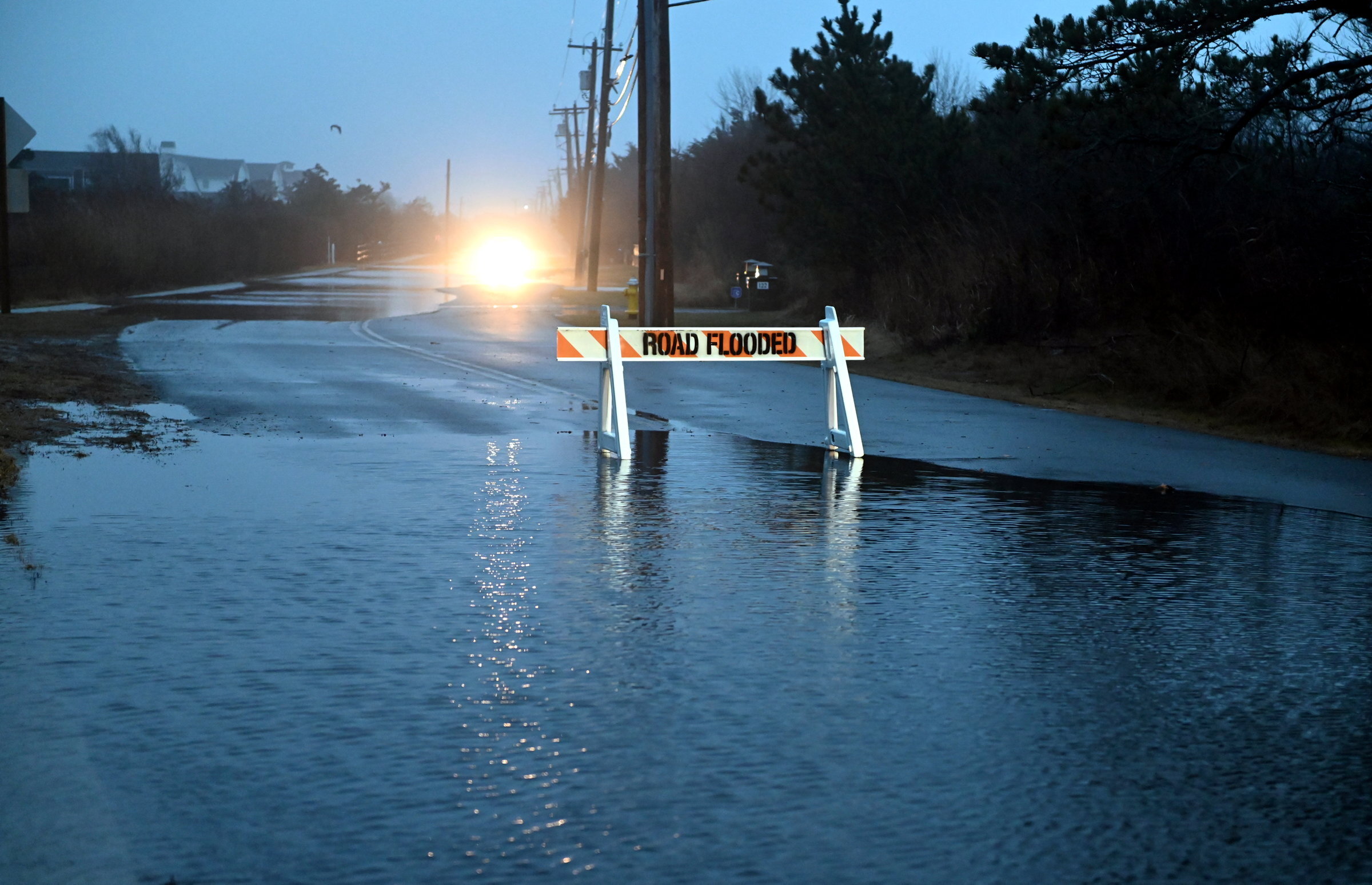
As sea levels rise, Long Island faces slow-moving crisis, experts say
The city of Long Beach, just a half-mile wide at its broadest point, always has been troubled by intermittent flooding. It can get battered from both sides, with storms and high tides coming in from the ocean to the south and water overtaking the lowest bulkheads on the bay that lies on the city’s north side. A few times, during some of the biggest storms of the past century — the hurricane of 1938, Donna in 1960, Superstorm Sandy in 2012 — water poured in from both sides and the ocean met the bay.
Those devastating storms could be merely a prelude for what’s to come. The seas are rising, and the pace is accelerating. According to the National Oceanic and Atmospheric Administration, the ocean along U.S. coastlines has risen about a foot in the past century. Over the next 25 years, sea levels around Long Island are expected to rise 13 to 25 inches — and as much as 69 inches by the end of the century, according to the state Department of Environmental Conservation.
In the coming decades, rising seas are expected to reshape the familiar contours of the coasts and disrupt the most basic infrastructure of daily life, from roadways to well-water supplies, and from the electrical grid to wastewater systems. While optimists say Long Island is not going to sink under the waves any time soon, climate scientists warn that preparations have been too sluggish.
Combined with more frequent and powerful storms, higher sea levels will compel Long Beach, along with every coastal town across the globe, to plan for a much wetter future, according to climate experts.
The response to this accelerating crisis is “clearly falling short of what’s needed, because of the scale of the challenge,” Rachel Cleetus, climate program policy director at the Union of Concerned Scientists, a nonprofit research and advocacy organization, told Newsday. “And now we have a very short amount of time.”
Climatologists’ predictions for sea-level rise are based on models of future carbon emissions. If industrialized nations fail to curb their appetite for fossil fuels, and land ice melts more quickly, those predictions become more dire.
When the DEC proposed updated projections for Long Island’s coastlines last year, the agency added new “rapid ice melt” estimates of 83 inches by the 2080s and 114 inches by the end of the century.
For all these grim forecasts, Long Island is not going to be swallowed whole by the Atlantic Ocean, said Henry Bokuniewicz, a professor at the School of Marine and Atmospheric Sciences at Stony Brook University.
“Even with the worst-case scenarios, the immediate impacts of sea-level rise are confined to a fairly small band around the shore,” Bokuniewicz said.
Still, for some living in that small band, the consequences of rising sea levels are already a distasteful reality.
Louie Blandon, 36, said rainfall backs up the cesspools in his Mastic Beach neighborhood, so everyone has to avoid flushing in wet weather. “It stinks for a couple days following a rainstorm or a high tide,” he said.
According to climate scientists and environmental engineers, there’s little doubt other changes are coming. The only question is how soon.
They say shorelines will recede and some land closest to sea level will slip underwater. East Hampton could become “a series of islands with permanent submergence of low-lying areas” by 2070, according to the town's resiliency plan.
Coastal areas will encounter more sunny-day" flooding — from high tides alone. According to New York State’s climate impact assessment, released in February, areas along Long Island Sound that experience four high tide floods a year could have 50 to 90 a year by the 2040s.
Climate scientists and government agencies also predict:
Salt water will infiltrate septic systems, causing fetid conditions after heavy rains and worsening the trickle of sewage into nearby waterways, Parts of the Long Island Rail Road's Montauk branch tracks on the East End will begin to flood in 20 to 70 years, As salt water periodically or permanently inundates inland natural areas, mature trees and other vegetation will die off, creating “ghost forests” of gray, leafless trunks, Coastal species already in decline, such as salt marsh sparrows, piping plovers and diamondback terrapins, may disappear as the habitats they rely on — grassy dunes and wetlands — are overtaken by the sea, Houses that experience chronic flooding will become uninsurable and lose value, leading to foreclosures, If flood-prone neighborhoods begin to empty out, villages and towns will lose tax revenue, Maintaining drainage systems and roads that flood persistently also will strain municipalities’ finances, Critical infrastructure such as electrical substations built close to the coast will have to be abandoned and new ones built on higher ground, .
Very few communities on Long Island have prepared climate vulnerability assessments of particular risks and how they might be addressed. The Town of East Hampton prepared one in 2021, but such studies are expensive and time-consuming and out of reach for many towns. Starting this fall, the New York Sea Grant, in collaboration with the Cornell Cooperative Extension, will offer funds for towns to hire environmental engineering firms for climate vulnerability studies.
New York Sea Grant and Long Island Sound Study also have developed an online “resilience resource hub” to educate Long Islanders about the risks and ways to manage them.
Coastal towns must start “asking questions about how they can better prepare for changes,” said Sarah Schaeffer-Brown, a resiliency specialist at New York Sea Grant, “so we are not caught off guard when something big does happen again. Which it will.”
So far, a range of protective strategies have been used to manage higher waters and stronger storms, from restoring dunes and salt marshes to raising houses and armoring shorelines with bulkheads and sea walls. A few substantial engineering projects have been proposed, such as building a series of sea gates across South Shore inlets that could be shut when a nor’easter is on the way.
None of these approaches is simple or foolproof. Some communities have devoted time and funding to restoring dunes, for example, only to see them swept away again in the next large storm.
Coastal wetlands are among the best defenses against rising seas, but millions of acres of wetlands along the East Coast have been overtaken by human development. The remaining marshes could shift inland, but too often there is no place for them to move to, as inland areas already have been claimed by asphalt and lawn grass.
Hard barriers such as walls and groins would have to circle the Island to prevent the sea from channeling into unprotected areas. And these structures don’t address the salt water that seeps in from below as sea levels rise.
Climate experts say the rising seas will require shoreline communities to make difficult decisions. Some places will someday be unsafe, and some buildings will not be salvageable.
The U.S. Army Corps of Engineers has spent tens of millions of dollars to forestall further erosion around the Montauk Point lighthouse, which was nearly 300 feet from the cliffs when it was built in 1796 but just 56 feet away today. But the lighthouse is a national historic landmark and a beloved icon; other structures without the same cultural prominence may not fare as well in a cost-benefit analysis.
“There’s no doubt that we have the engineering capability to save almost anything we want,” said Bokuniewicz, the Stony Brook University professor. But “you may end up with a completely artificial shoreline. You can do it, but there’s a cost to it.”
At the very least, Schaeffer-Brown said there should be “no more development along the shoreline.” Any existing open space on the waterfront should remain “a natural buffer to rising sea levels and storms.”
Despite the risks, the appeal of waterfront properties seems unshaken, at least among those affluent enough to pay high insurance rates and weather expensive repairs. And zoning rules haven’t kept up with the new realities. Last year, a six-bedroom, 4,800-square-foot house was permitted and built just off Ditch Plains Beach in Montauk, and at least two more of similar size are nearing completion or planned close by.
Others are leaving low-lying neighborhoods. Jason Spark, 30, who lives in Mastic, said the one-story house he rents takes on water every couple of months. “We have to get ourselves a hotel and stay away for a little bit till it goes down,” he said. His mother “got so tired of that, so she moved,” and he, too, has considered moving to higher ground.
Some homeowners are raising their houses on pillars so floodwaters flow harmlessly under their dry living rooms, and some municipalities, such as Long Beach, require newly constructed or substantially renovated houses to be raised.
But climate experts note that even these modifications don’t fully address the flooding problem. “I could raise my house and move out for five days every time there's a hurricane,” said Alison Branco, climate adaptation director at The Nature Conservancy in New York. But when streets are flooding, “Soon, I'm not going to be able to get in and out of my raised house half the time. So now am I happy?”
Long Islanders who live in shoreline communities already speak of the future with a tone of mourning. When Jasie Britton, 53, and her husband bought their house in Ditch Plains in 2005, they knew it was in a risky spot. “I guess we thought we had another 30 years,” she said. After last winter’s damaging storms, she’s not sure.
Her 14-year-old son especially worries about what might be lost as he grows up. “Montauk is his home and he is so saddened by the idea of the beach being gone, the house being gone, the neighborhood being gone,” Britton said. “That’s been the hardest thing, watching him be so devastated by this.”
Branco thinks that sooner or later, many coastal towns will have to accept the inevitability of managed retreat: moving vulnerable buildings away from the shoreline and restoring coastal wetlands.
“Most of us live on Long Island because we like being near the water. But the way we're living with the water right now is just not sustainable,” she said. “Fortunately, we don't have to vacate the Island. We just need to back up a little bit.”
The city of Long Beach, just a half-mile wide at its broadest point, always has been troubled by intermittent flooding. It can get battered from both sides, with storms and high tides coming in from the ocean to the south and water overtaking the lowest bulkheads on the bay that lies on the city’s north side. A few times, during some of the biggest storms of the past century — the hurricane of 1938, Donna in 1960, Superstorm Sandy in 2012 — water poured in from both sides and the ocean met the bay.
Those devastating storms could be merely a prelude for what’s to come. The seas are rising, and the pace is accelerating. According to the National Oceanic and Atmospheric Administration, the ocean along U.S. coastlines has risen about a foot in the past century. Over the next 25 years, sea levels around Long Island are expected to rise 13 to 25 inches — and as much as 69 inches by the end of the century, according to the state Department of Environmental Conservation.
In the coming decades, rising seas are expected to reshape the familiar contours of the coasts and disrupt the most basic infrastructure of daily life, from roadways to well-water supplies, and from the electrical grid to wastewater systems. While optimists say Long Island is not going to sink under the waves any time soon, climate scientists warn that preparations have been too sluggish.
Combined with more frequent and powerful storms, higher sea levels will compel Long Beach, along with every coastal town across the globe, to plan for a much wetter future, according to climate experts.
WHAT TO KNOW
- Over the next 25 years, sea levels around Long Island are expected to rise 13 to 25 inches and as much as 69 inches by the end of the century, according to the state Department of Environmental Conservation.
- The rising levels are expected to reshape the contours of the coasts, disrupt basic infrastructure and compel communities to prepare for a much wetter future.
- Very few communities on Long Island have prepared climate vulnerability assessments of particular risks and how they might be addressed.
The response to this accelerating crisis is “clearly falling short of what’s needed, because of the scale of the challenge,” Rachel Cleetus, climate program policy director at the Union of Concerned Scientists, a nonprofit research and advocacy organization, told Newsday. “And now we have a very short amount of time.”
Long Island underwater?
Ransom Beach in Bayville was submerged as waves from Superstorm Sandy pummeled the North Shore on Oct. 29, 2012. Credit: Danielle Finkelstein
Climatologists’ predictions for sea-level rise are based on models of future carbon emissions. If industrialized nations fail to curb their appetite for fossil fuels, and land ice melts more quickly, those predictions become more dire.
When the DEC proposed updated projections for Long Island’s coastlines last year, the agency added new “rapid ice melt” estimates of 83 inches by the 2080s and 114 inches by the end of the century.
For all these grim forecasts, Long Island is not going to be swallowed whole by the Atlantic Ocean, said Henry Bokuniewicz, a professor at the School of Marine and Atmospheric Sciences at Stony Brook University.
“Even with the worst-case scenarios, the immediate impacts of sea-level rise are confined to a fairly small band around the shore,” Bokuniewicz said.
Still, for some living in that small band, the consequences of rising sea levels are already a distasteful reality.
Louie Blandon, 36, said rainfall backs up the cesspools in his Mastic Beach neighborhood, so everyone has to avoid flushing in wet weather. “It stinks for a couple days following a rainstorm or a high tide,” he said.
According to climate scientists and environmental engineers, there’s little doubt other changes are coming. The only question is how soon.
They say shorelines will recede and some land closest to sea level will slip underwater. East Hampton could become “a series of islands with permanent submergence of low-lying areas” by 2070, according to the town's resiliency plan.
Coastal areas will encounter more sunny-day" flooding — from high tides alone. According to New York State’s climate impact assessment, released in February, areas along Long Island Sound that experience four high tide floods a year could have 50 to 90 a year by the 2040s.
Climate scientists and government agencies also predict:
- Salt water will infiltrate septic systems, causing fetid conditions after heavy rains and worsening the trickle of sewage into nearby waterways.
- Parts of the Long Island Rail Road's Montauk branch tracks on the East End will begin to flood in 20 to 70 years.
- As salt water periodically or permanently inundates inland natural areas, mature trees and other vegetation will die off, creating “ghost forests” of gray, leafless trunks.
- Coastal species already in decline, such as salt marsh sparrows, piping plovers and diamondback terrapins, may disappear as the habitats they rely on — grassy dunes and wetlands — are overtaken by the sea.
- Houses that experience chronic flooding will become uninsurable and lose value, leading to foreclosures. If flood-prone neighborhoods begin to empty out, villages and towns will lose tax revenue.
- Maintaining drainage systems and roads that flood persistently also will strain municipalities’ finances.
- Critical infrastructure such as electrical substations built close to the coast will have to be abandoned and new ones built on higher ground.
Few communities have a plan
An aerial view of homes in Westhampton with flooded lawns from the high tide in Shinnecock Bay caused by Superstorm Sandy on Oct. 30, 2012. Credit: Doug Kuntz
Very few communities on Long Island have prepared climate vulnerability assessments of particular risks and how they might be addressed. The Town of East Hampton prepared one in 2021, but such studies are expensive and time-consuming and out of reach for many towns. Starting this fall, the New York Sea Grant, in collaboration with the Cornell Cooperative Extension, will offer funds for towns to hire environmental engineering firms for climate vulnerability studies.
New York Sea Grant and Long Island Sound Study also have developed an online “resilience resource hub” to educate Long Islanders about the risks and ways to manage them.
Coastal towns must start “asking questions about how they can better prepare for changes,” said Sarah Schaeffer-Brown, a resiliency specialist at New York Sea Grant, “so we are not caught off guard when something big does happen again. Which it will.”
So far, a range of protective strategies have been used to manage higher waters and stronger storms, from restoring dunes and salt marshes to raising houses and armoring shorelines with bulkheads and sea walls. A few substantial engineering projects have been proposed, such as building a series of sea gates across South Shore inlets that could be shut when a nor’easter is on the way.
While rebuilding their Seaford house, which had been destroyed by Superstorm Sandy, the owners also had it elevated, left. Machinery moves sand for a shoreline improvement project in Riverhead in November, right. Credit: Daniel Goodrich; Newsday/Steve Pfost
None of these approaches is simple or foolproof. Some communities have devoted time and funding to restoring dunes, for example, only to see them swept away again in the next large storm.
Coastal wetlands are among the best defenses against rising seas, but millions of acres of wetlands along the East Coast have been overtaken by human development. The remaining marshes could shift inland, but too often there is no place for them to move to, as inland areas already have been claimed by asphalt and lawn grass.
Hard barriers such as walls and groins would have to circle the Island to prevent the sea from channeling into unprotected areas. And these structures don’t address the salt water that seeps in from below as sea levels rise.
Raising homes, moving away
An aerial view of Lindenhurst in 2017 shows some of the properties that no longer have homes on them because residents sold them as part of an enhanced buyout program after Superstorm Sandy. Credit: All Island Aerial/Kevin P. Coughlin
Climate experts say the rising seas will require shoreline communities to make difficult decisions. Some places will someday be unsafe, and some buildings will not be salvageable.
The U.S. Army Corps of Engineers has spent tens of millions of dollars to forestall further erosion around the Montauk Point lighthouse, which was nearly 300 feet from the cliffs when it was built in 1796 but just 56 feet away today. But the lighthouse is a national historic landmark and a beloved icon; other structures without the same cultural prominence may not fare as well in a cost-benefit analysis.
“There’s no doubt that we have the engineering capability to save almost anything we want,” said Bokuniewicz, the Stony Brook University professor. But “you may end up with a completely artificial shoreline. You can do it, but there’s a cost to it.”
At the very least, Schaeffer-Brown said there should be “no more development along the shoreline.” Any existing open space on the waterfront should remain “a natural buffer to rising sea levels and storms.”
Despite the risks, the appeal of waterfront properties seems unshaken, at least among those affluent enough to pay high insurance rates and weather expensive repairs. And zoning rules haven’t kept up with the new realities. Last year, a six-bedroom, 4,800-square-foot house was permitted and built just off Ditch Plains Beach in Montauk, and at least two more of similar size are nearing completion or planned close by.
Erosion and storm damage on Ditch Plains Beach in Montauk in January. Credit: Randee Daddona
Others are leaving low-lying neighborhoods. Jason Spark, 30, who lives in Mastic, said the one-story house he rents takes on water every couple of months. “We have to get ourselves a hotel and stay away for a little bit till it goes down,” he said. His mother “got so tired of that, so she moved,” and he, too, has considered moving to higher ground.
Some homeowners are raising their houses on pillars so floodwaters flow harmlessly under their dry living rooms, and some municipalities, such as Long Beach, require newly constructed or substantially renovated houses to be raised.
But climate experts note that even these modifications don’t fully address the flooding problem. “I could raise my house and move out for five days every time there's a hurricane,” said Alison Branco, climate adaptation director at The Nature Conservancy in New York. But when streets are flooding, “Soon, I'm not going to be able to get in and out of my raised house half the time. So now am I happy?”
Long Islanders who live in shoreline communities already speak of the future with a tone of mourning. When Jasie Britton, 53, and her husband bought their house in Ditch Plains in 2005, they knew it was in a risky spot. “I guess we thought we had another 30 years,” she said. After last winter’s damaging storms, she’s not sure.
Her 14-year-old son especially worries about what might be lost as he grows up. “Montauk is his home and he is so saddened by the idea of the beach being gone, the house being gone, the neighborhood being gone,” Britton said. “That’s been the hardest thing, watching him be so devastated by this.”
Branco thinks that sooner or later, many coastal towns will have to accept the inevitability of managed retreat: moving vulnerable buildings away from the shoreline and restoring coastal wetlands.
“Most of us live on Long Island because we like being near the water. But the way we're living with the water right now is just not sustainable,” she said. “Fortunately, we don't have to vacate the Island. We just need to back up a little bit.”

Prepare yourself for the 2024 hurricane season NewsdayTV meteorologists Bill Korbel and Rich Von Ohlen tell you what to expect this season.
Prepare yourself for the 2024 hurricane season NewsdayTV meteorologists Bill Korbel and Rich Von Ohlen tell you what to expect this season.