Sea levels rise on Long Island: How communities are tackling a potential crisis
The National Oceanic and Atmospheric Administration estimates sea levels around the contiguous U.S. coastline will rise by about a foot on average over the next 30 years. But it’s hard to fathom what that might look like, so NOAA has created an interactive map. Zoom in on Long Island, and as you click on 1 foot, 2 feet, 3 feet of sea-level rise, the map displays a widening ribbon circling the coasts — and that’s the land that will be permanently underwater.
As that ribbon expands in the real world, every coastal town will have its challenges and will need to find ways to address them. These three Long Island communities are working to get ahead of the crisis.
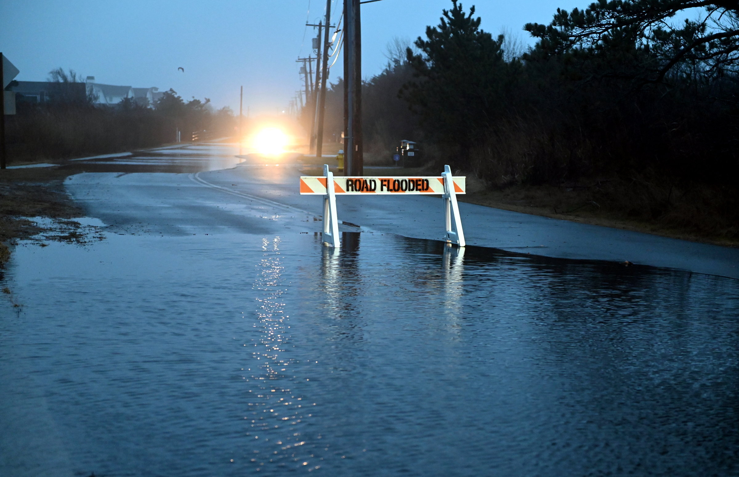
The stretch of West Park Avenue between New York and Nevada streets in Long Beach was “one of the worst areas for flooding” until a year ago, according to Joe Febrizio, the city’s commissioner of public works. “It would flood at every high tide, every rainstorm.”
Last summer, with a $6.5 million grant from the governor’s Office of Storm Recovery, the city installed a force main, a pressurized sewer system that collects water from the storm drains in the area and pumps it into the bay. The system is powerful enough to push the floodwater out against a strong high tide.
The pump is one element of a series of engineering projects intended to manage stormwater, safeguard critical infrastructure and keep residents safe in a storm.
On the city’s south side, close to the Lido Beach border, the city is reinforcing 1,000 feet of dunes that washed away during Superstorm Sandy, then were reconstructed by the U.S. Army Corps of Engineers in 2019 before being damaged again by the storms last fall and winter. Now workers are building the dunes a little higher and replanting beach grasses — plug by plug — to form a protective barrier against future storm surges.
On the North Shore, nearly all the bulkheads bordering city-owned properties have been raised to FEMA’s “base flood elevation” — high enough to withstand a 100-year storm. New zoning regulations require private property owners looking to rebuild their own bulkhead to meet the base flood elevation as well.
In the North Shore’s industrial zone, new bulkheads and a second force main pump will prevent flooding in the adjoining neighborhood, a low-income community that residents and city officials say persistently floods.
“The streets flood every time it rains,” said Star Smith, 45, as she waited on a brisk day in March for the school bus to drop off her son. She said East Pine Street, one block over from where she lives, was the worst.
“I want to get out of Long Beach, because it’s scary,” Smith said. “We’re going to be under water.”
That’s not predicted to happen anytime soon, and city manager Dan Creighton said the improvements should help the city withstand the next big storm. “Right now I think we’ll weather another Sandy,” Creighton said. But a 500-year storm?
Creighton said no one wants to think about retreat, but after Sandy everyone has to acknowledge that moving away from the shore may one day be necessary. “We’re at the spot where it’s still manageable, and we’ll stay until it’s not,” he said. “We’re doing everything we can to be sure we can stay here as long as we can.”
After Sandy barreled through the Shinnecock Nation’s peninsula, causing significant erosion and flood damage, the Nation began to take a hard look at how the climate crisis would alter its 800-acre territory.
A climate vulnerability assessment, prepared in 2019 in collaboration with the Peconic Bay Estuary, notes the coastal edges of the Nation’s territory, already a fraction of the lands that once were theirs, will be lost as the ocean moves inland. Parts of the peninsula, including a historic cemetery, already experience routine flooding, and the bluffs along the Great Peconic Bay and beaches on Shinnecock Bay have eroded.
In considering solutions, the question has always been, “What’s the best way to protect the Shinnecock shoreline using the natural elements around us?” said Shavonne Smith, environment director for the Shinnecock Nation.
After Sandy, the Shinnecock and the Cornell Cooperative Extension restored 3,000 feet of beachfront along Shinnecock Bay, strengthening dunes, planting sea grass and building an oyster reef to soften the force of incoming waves. The reefs also would improve water quality and provide habitat for marine species.
The project was completed in 2016, with the help of a grant from the National Wildlife Federation, but last winter’s storms washed much of their work away. “It’s disheartening but not unexpected,” Smith said. “We are dealing with the tremendous force and power of nature.”
Now, the Nation is working with the U.S. Geological Survey to determine if the reef should be extended or angled differently to offer greater protection. And a Nature Conservancy project is studying the salt marsh that borders some of the Shinnecock’s land — nature’s best defense against floodwater — to determine if it will be able to migrate as the seas creep closer.
The Shinnecock’s approach is “working with rather than working against nature,” Smith said. “There has to be a point where you acknowledge that you can’t control it.”
When a nor’easter sweeps across the Peconic Bay, heavy winds push the water against the flow of the Peconic River, flooding the downtown. The large parking lot that borders the river is frequently underwater, and in the heaviest storms, floodwaters lap against nearby buildings, including the historic Vail-Leavitt Music Hall — Long Island’s oldest theater — and East End Arts, a music and art gallery and school.
The Army Corps of Engineers surveyed Riverhead’s water problems and outlined possible fixes such as levees, walls, locks and dykes. With the help of Urban Design Associates, a Pittsburgh-based firm that specializes in resilient design, the town landed on a solution: flood protection as urban renewal.
By the end of this year, Riverhead expects to break ground on an expansive riverfront revitalization project that will provide green space for the community — in particular for Riverhead’s lower-income residents, who lack such amenities — and an attraction for visitors as well.
The parking lot will no longer be a significant feature of the downtown. “It was a poor use of the riverfront,” said Dawn Thomas, the town’s community development director. “It really should be public space.”
The town bought and then demolished three rundown buildings, leaving open space that will be part of a large public square running from Main Street down to the river. The present gradual slope to the water will be regraded as a series of terraces, raised sufficiently from the river’s edge to form a flood barrier. Far from a sterile armored edifice, the terraces will feature an amphitheater, a playground (with structures designed for those with mobility challenges) and a splash pad, an open plaza with shade trees and a sculpture garden. Drawings for the project show tented farmers’ stalls and tables and benches for picnicking and people-watching.
The asphalt parking lot and its persistent drainage problems will be replaced by landscaping and new permeable surfacing, said Ken Testa, Riverhead’s assistant engineer. Areas like the playground and amphitheater can be temporarily inundated without damage and all new buildings will be designed to withstand flooding.
The project has been funded largely through state grants, including $400,000 from the Brownfield Opportunity Area program and $10 million through the Downtown Revitalization Initiative.
“The beauty of this is it creates public space and flood mitigation in the same project,” Thomas said.
The National Oceanic and Atmospheric Administration estimates sea levels around the contiguous U.S. coastline will rise by about a foot on average over the next 30 years. But it’s hard to fathom what that might look like, so NOAA has created an interactive map. Zoom in on Long Island, and as you click on 1 foot, 2 feet, 3 feet of sea-level rise, the map displays a widening ribbon circling the coasts — and that’s the land that will be permanently underwater.
As that ribbon expands in the real world, every coastal town will have its challenges and will need to find ways to address them. These three Long Island communities are working to get ahead of the crisis.
Long Beach: Shoring up critical infrastructure
Beachgoers watch the effort to rebuild the beach after years of erosion at Grand Avenue and New York Avenue in Long Beach on Aug. 14, 2018. Credit: Newsday/J. Conrad Williams Jr.
The stretch of West Park Avenue between New York and Nevada streets in Long Beach was “one of the worst areas for flooding” until a year ago, according to Joe Febrizio, the city’s commissioner of public works. “It would flood at every high tide, every rainstorm.”
Last summer, with a $6.5 million grant from the governor’s Office of Storm Recovery, the city installed a force main, a pressurized sewer system that collects water from the storm drains in the area and pumps it into the bay. The system is powerful enough to push the floodwater out against a strong high tide.
WHAT TO KNOW
- Long Island communities are using various methods to get ahead of rising sea levels. Long Beach, for instance, is undertaking engineering projects to manage stormwater, safeguard critical infrastructure and keep residents safe in storms.
- The Shinnecock Nation is trying to determine if oyster reefs built after Superstorm Sandy should be extended or angled differently to offer greater protection, and whether salt marsh that borders their land will be able to move inland as seas creep closer.
- Riverhead expects to break ground on an expansive riverfront revitalization project that will provide green space and flood mitigation.
The pump is one element of a series of engineering projects intended to manage stormwater, safeguard critical infrastructure and keep residents safe in a storm.
On the city’s south side, close to the Lido Beach border, the city is reinforcing 1,000 feet of dunes that washed away during Superstorm Sandy, then were reconstructed by the U.S. Army Corps of Engineers in 2019 before being damaged again by the storms last fall and winter. Now workers are building the dunes a little higher and replanting beach grasses — plug by plug — to form a protective barrier against future storm surges.
On the North Shore, nearly all the bulkheads bordering city-owned properties have been raised to FEMA’s “base flood elevation” — high enough to withstand a 100-year storm. New zoning regulations require private property owners looking to rebuild their own bulkhead to meet the base flood elevation as well.
In the North Shore’s industrial zone, new bulkheads and a second force main pump will prevent flooding in the adjoining neighborhood, a low-income community that residents and city officials say persistently floods.
I want to get out of Long Beach, because it’s scary. We’re going to be underwater.
— Long Beach resident Star Smith
“The streets flood every time it rains,” said Star Smith, 45, as she waited on a brisk day in March for the school bus to drop off her son. She said East Pine Street, one block over from where she lives, was the worst.
“I want to get out of Long Beach, because it’s scary,” Smith said. “We’re going to be under water.”
That’s not predicted to happen anytime soon, and city manager Dan Creighton said the improvements should help the city withstand the next big storm. “Right now I think we’ll weather another Sandy,” Creighton said. But a 500-year storm?
Creighton said no one wants to think about retreat, but after Sandy everyone has to acknowledge that moving away from the shore may one day be necessary. “We’re at the spot where it’s still manageable, and we’ll stay until it’s not,” he said. “We’re doing everything we can to be sure we can stay here as long as we can.”
Shinnecock Nation: Working with nature
An oyster reef installed to protect from floods at the Shinnecock Indian Nation on March 21. Credit: Morgan Campbell
After Sandy barreled through the Shinnecock Nation’s peninsula, causing significant erosion and flood damage, the Nation began to take a hard look at how the climate crisis would alter its 800-acre territory.
A climate vulnerability assessment, prepared in 2019 in collaboration with the Peconic Bay Estuary, notes the coastal edges of the Nation’s territory, already a fraction of the lands that once were theirs, will be lost as the ocean moves inland. Parts of the peninsula, including a historic cemetery, already experience routine flooding, and the bluffs along the Great Peconic Bay and beaches on Shinnecock Bay have eroded.
What’s the best way to protect the Shinnecock shoreline using the natural elements around us?
—Shavonne Smith, environment director for the Shinnecock Nation
In considering solutions, the question has always been, “What’s the best way to protect the Shinnecock shoreline using the natural elements around us?” said Shavonne Smith, environment director for the Shinnecock Nation.
After Sandy, the Shinnecock and the Cornell Cooperative Extension restored 3,000 feet of beachfront along Shinnecock Bay, strengthening dunes, planting sea grass and building an oyster reef to soften the force of incoming waves. The reefs also would improve water quality and provide habitat for marine species.
The project was completed in 2016, with the help of a grant from the National Wildlife Federation, but last winter’s storms washed much of their work away. “It’s disheartening but not unexpected,” Smith said. “We are dealing with the tremendous force and power of nature.”
Now, the Nation is working with the U.S. Geological Survey to determine if the reef should be extended or angled differently to offer greater protection. And a Nature Conservancy project is studying the salt marsh that borders some of the Shinnecock’s land — nature’s best defense against floodwater — to determine if it will be able to migrate as the seas creep closer.
The Shinnecock’s approach is “working with rather than working against nature,” Smith said. “There has to be a point where you acknowledge that you can’t control it.”
Riverhead: Flood mitigation as urban renewal
Flooding in downtown Riverhead on April 4. Credit: Tom Lambui
When a nor’easter sweeps across the Peconic Bay, heavy winds push the water against the flow of the Peconic River, flooding the downtown. The large parking lot that borders the river is frequently underwater, and in the heaviest storms, floodwaters lap against nearby buildings, including the historic Vail-Leavitt Music Hall — Long Island’s oldest theater — and East End Arts, a music and art gallery and school.
The Army Corps of Engineers surveyed Riverhead’s water problems and outlined possible fixes such as levees, walls, locks and dykes. With the help of Urban Design Associates, a Pittsburgh-based firm that specializes in resilient design, the town landed on a solution: flood protection as urban renewal.
By the end of this year, Riverhead expects to break ground on an expansive riverfront revitalization project that will provide green space for the community — in particular for Riverhead’s lower-income residents, who lack such amenities — and an attraction for visitors as well.
The parking lot will no longer be a significant feature of the downtown. “It was a poor use of the riverfront,” said Dawn Thomas, the town’s community development director. “It really should be public space.”
The beauty of this is it creates public space and flood mitigation in the same project.
—Dawn Thomas, Riverhead’s community development director
The town bought and then demolished three rundown buildings, leaving open space that will be part of a large public square running from Main Street down to the river. The present gradual slope to the water will be regraded as a series of terraces, raised sufficiently from the river’s edge to form a flood barrier. Far from a sterile armored edifice, the terraces will feature an amphitheater, a playground (with structures designed for those with mobility challenges) and a splash pad, an open plaza with shade trees and a sculpture garden. Drawings for the project show tented farmers’ stalls and tables and benches for picnicking and people-watching.
The asphalt parking lot and its persistent drainage problems will be replaced by landscaping and new permeable surfacing, said Ken Testa, Riverhead’s assistant engineer. Areas like the playground and amphitheater can be temporarily inundated without damage and all new buildings will be designed to withstand flooding.
The project has been funded largely through state grants, including $400,000 from the Brownfield Opportunity Area program and $10 million through the Downtown Revitalization Initiative.
“The beauty of this is it creates public space and flood mitigation in the same project,” Thomas said.
'It's disappointing and it's unfortunate' Suffolk Police Officer David Mascarella is back on the job after causing a 2020 crash that severely injured Riordan Cavooris, then 2. NewsdayTV's Andrew Ehinger and Newsday investigative reporter Paul LaRocco have the story.
'It's disappointing and it's unfortunate' Suffolk Police Officer David Mascarella is back on the job after causing a 2020 crash that severely injured Riordan Cavooris, then 2. NewsdayTV's Andrew Ehinger and Newsday investigative reporter Paul LaRocco have the story.