Long Island weather: Rainy Saturday followed by sunny Sunday
Weather forecast for Saturday, July 30, 2017 Credit: Newsday
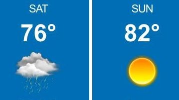
Light rain across Long Island on Saturday morning is expected to taper off around noon, but clouds and a slight chance of more showers will linger until the evening hours along with a breezy wind, the National Weather Service said.
Temperatures will peak in the mid-to-high 70s, according to the weather service.
Only 25¢ for 5 months
Light rain across Long Island on Saturday morning is expected to taper off around noon, but clouds and a slight chance of more showers will linger until the evening hours along with a breezy wind, the National Weather Service said.
Temperatures will peak in the mid-to-high 70s, according to the weather service.
Bruce Avery, a meteorologist with News 12 Long Island, said temperatures Saturday will be below the normal of 82 degrees. There’s a chance that midday Saturday, the clouds may break for some sunny periods by the afternoon, Avery said.
A “big storm is going right around us,” Avery said.
The weather service issued a high rip-current risk statement for Long Island and New York City beaches, effective from 8 a.m. Saturday until the nighttime. Surf height is expected to reach 4 to 5 feet.
Saturday night will be mostly clear with lows in the low 60s. A breezy, northwest wind is expected to blow around 15-23 mph. In some of the more traditionally cool areas, overnight temperatures there could drop into the 50s, Avery said.
Sunday’s forecast shows “a lovely day” with sunny weather, no precipitation, and highs reaching the low 80s, Avery said. A northeast wind will keep breezes at around 10 to 17 mph.
FeedMe: Apple cider doughnuts ... Ethnic grocers ... Get the latest news and more great videos at NewsdayTV